In recent years, Japan has experienced an increasing number of large-scale and wide-area river floods and landslide disasters triggered by localized torrential rainfall and typhoons, causing severe human losses and substantial economic damage across many regions. Under these situations, critical issues have emerged regarding the timing and effectiveness of disaster-related public information. In some communities, residents may not develop a sufficient sense of urgency when official information is communicated, which can lead to delays in taking protective action. In other situations, heavy rainfall events escalate more rapidly than expected, and municipalities may struggle to issue timely official instructions and alerts as conditions deteriorate. These challenges indicate that, beyond simply providing hazard forecasts, municipalities need practical decision support that helps them understand evolving risk and communicate appropriate guidance at the right timing.
This project is one of the initiatives addressing the theme “Promoting disaster risk–informed actions” under the third phase of the Strategic Innovation Promotion Program (SIP) led by the Cabinet Office of Japan. The overarching goal of this research effort is to achieve zero loss of life due to delayed protective actions during heavy rainfall disasters. To realize this goal, the project focuses on delivering essential disaster risk information to municipalities at appropriate times, enabling local governments to make evidence-based decisions on when to issue official public instructions and warnings, and thereby reducing the likelihood that people remain in hazardous areas too long.
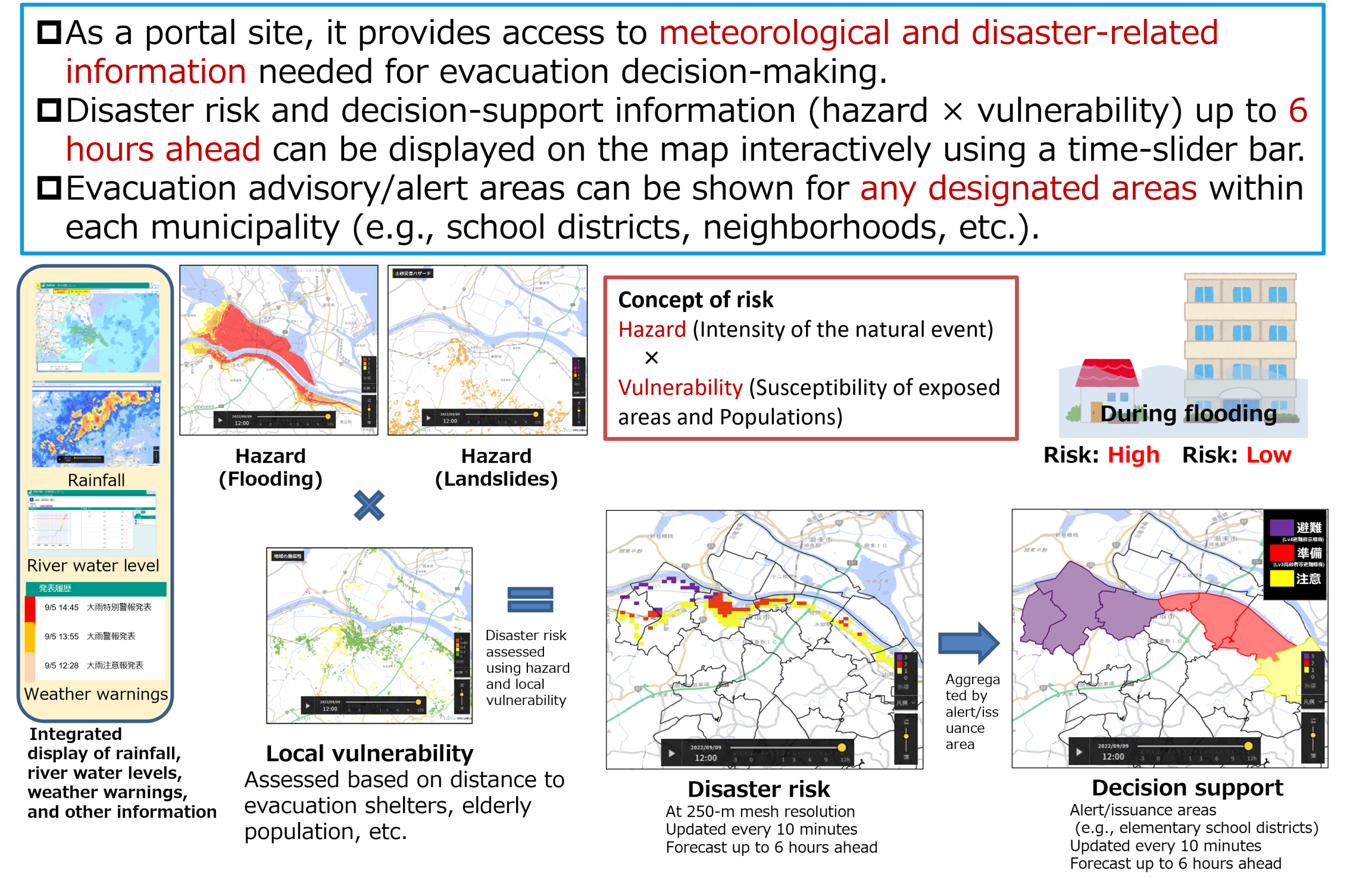
Specifically, we are developing an integrated system that supports local governments’ disaster response by assessing human risk in real time. This system evaluates near-future disaster information—such as the risk of flooding and landslides occurring within the next few hours and their potential severity—derived from forecasted rainfall and related meteorological data. Furthermore, it incorporates the vulnerability of the areas where disasters may occur. By combining forecast-based hazard indicators with vulnerability characteristics, the system provides a real-time estimate of potential human impact risk and presents the results in a form that is actionable for municipal decision-making.
The system being developed is called IDR4M (Integrated-system of Disaster Reduction for Municipalities). By implementing IDR4M, municipalities will be able to monitor how the risk of human harm changes moment by moment and how it may evolve several hours into the future. This forward-looking understanding can support local governments in determining the most appropriate timing for issuing official instructions and public notifications, with the aim of preventing casualties caused by delayed responses.
In parallel, to ensure that the project can support municipalities that already operate their own disaster management systems, we are also developing an application programming interface (API) in collaboration with private companies and other partners. This API will provide disaster risk information in an interoperable format so that it can be integrated into diverse municipal platforms. Through these combined efforts, the project seeks to strengthen municipal decision-making and contribute to safer and more resilient communities during extreme rainfall events.